Powerful hurricane to strike Mexico; slow movement raises heavy-rain threat
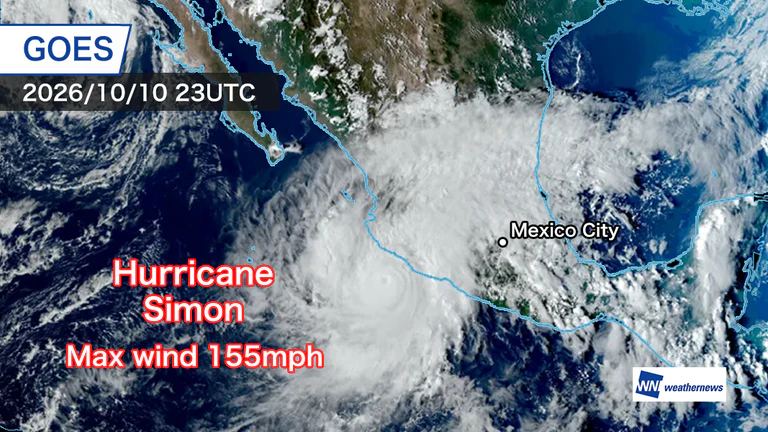
Maximum winds near the center reach 155 mph
Hurricane Isaias in the Gulf of Mexico has only recently made landfall, and now a hurricane is approaching Mexico’s Pacific coast.
Hurricane Simon formed over the eastern Pacific off Mexico and rapidly intensified as warm sea-surface temperatures and wind conditions favored its development.
According to an analysis by the U.S. National Hurricane Center (NHC), as of the night of the 10th local time, the storm had a central pressure of 928 hPa and maximum winds of 155 mph. It remained a Category 4 hurricane, the second-highest of the five categories.
Flooding and other impacts already reported
As the hurricane approaches, small rivers that are usually dry have overflowed in the resort city of Acapulco, inundating the commercial area around El Morro Beach.
High waves and swells have also been observed along the coast of neighboring Ixtapa-Zihuatanejo.
Firefighters and emergency response teams are working to address flooding and protect residents. Mexico’s civil protection authorities have issued weather alerts and are urging farmers, livestock producers, fishers and coastal residents to evacuate or follow instructions.
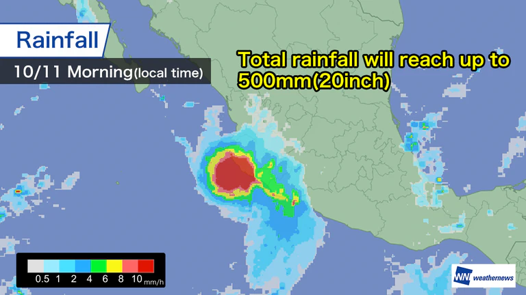
Major disasters possible from heavy rain and storm surge
Hurricane Simon is forecast to continue moving north at less than 10 km/h, approaching and making landfall from Colima toward Jalisco.
Total rainfall could reach 250–500 mm (10–20 inches), especially in mountainous areas, with localized amounts possibly exceeding 700 mm (30 inches).
The risk of dangerous storm surge and coastal flooding, as well as flash floods and large-scale landslides in mountainous areas, is extremely high. Mountainous terrain is expected to contribute to continued heavy rain inland, and close vigilance remains necessary.
The National Hurricane Center and local authorities have issued hurricane warnings for coastal areas, strongly urging people to prepare for high waves, landslides and flooding, and to evacuate early.

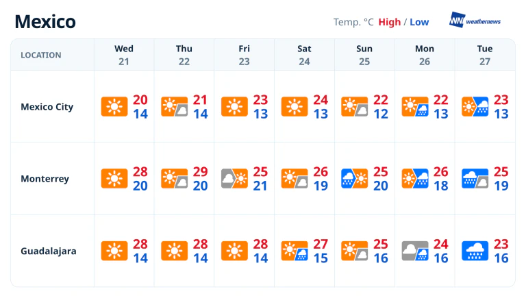
- Wed, 21/10Max 20° Min 14°

- Thu, 22/10Max 21° Min 14°

- Fri, 23/10Max 23° Min 12°
- Sat, 24/10Max 23° Min 12°
- Sun, 25/10Max 21° Min 12°
- Mon, 26/10Max 23° Min 12°
- Tue, 27/10Max 22° Min 13°

Latest News