Typhoon formation forecast: If Typhoon No. 32 forms, it would be the highest total in 32 years, since 1994
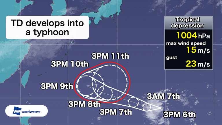
▼ Tropical depression | 3 p.m. Friday, November 6
- Center: Mariana Islands
- Movement: Northwest at 25 km/h
- Central pressure: 1004 hPa
- Maximum wind speed: 15 m/s (near the center)
- Maximum gust: 23 m/s
The tropical depression, which formed at 9 p.m. Thursday, November 5, is increasingly likely to strengthen and develop into a typhoon.
The forecast track shows it moving generally westward for a while, as Typhoon No. 31 did. Around Monday, November 9, it is expected to change course and head east instead.
From Tuesday, November 10, onward, the forecast area is large and uncertainty about the track is considerable. Depending on its track, the system could affect the Ogasawara Islands from the middle of next week onward, so its progress bears watching.

Annual typhoon formation rankings
- 1st: 39 — 1967
- 2nd: 36 — 1994, 1971
- 4th: 35 — 1966
- 5th: 34 — 1964
- 6th: 32 — 1989, 1974, 1965 (Records from 1951 onward)
Typhoons have been forming at a notably high pace in 2026, with the cumulative total through the end of October about 9 above average.
If another typhoon forms, it will be called Typhoon No. 32, following Typhoon No. 31 (In-fa), which formed on Saturday, October 24. It would be the first time since 1994, 32 years ago, that the annual number of typhoons has reached 32. It would also be the first time this century and the ninth such case in records dating back to 1951.
Typhoon formations and approaches to Japan both tend to become less frequent in November, but areas such as the Ogasawara Islands and Okinawa still cannot let their guard down.

- Sat, 07/11Max 7° Min -1°

- Sun, 08/11Max 8° Min 2°

- Mon, 09/11Max 11° Min 4°

- Tue, 10/11Max 13° Min 2°
- Wed, 11/11Max 17° Min 5°
- Thu, 12/11Max 18° Min 6°
- Fri, 13/11Max 18° Min 7°
Latest News