
2009.09.08
GIC Weekly Report for the Arctic Region Vol.6
Both passages nearly open
Topic of the Week
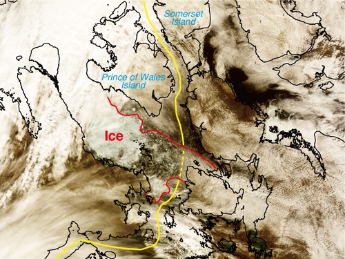
Figure 1. Modis image of the North Western passage in the Canadian Arctic West showing a possible future route between the Prince Of Wales Island and the Somerset island. (click to enlarge)
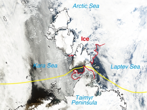
Figure 2. Modis image of the North Eastern passage at the Taimyr peninsula showing a possible future route between the Bolshevik island and Chelyuskin on the main land. (click to enlarge)
Sea Ice is expected to be at its lowest through the next few weeks as past annual trends show a minimum sea ice extent for the Arctic region being reached at this time of year. However ice is continuing to melt suggesting that the North Eastern and possibly the North Western passages may still open this year. The Eastern passage is now only blocked by a small area of sea ice within the Laptev Sea along the coast of Severnaya Zemlya and the adjacent islands (FIGURE 2), this area is continuing to melt, particularly to the western side of the islands, resulting in the clearing of ice within the Kara Sea North, which borders the Laptev Sea. The Global Forecasting Model shows that throughout the week a north westerly circulation will bring temperatures down to between 00C and -50C.
The North Western passage also continues to clear, with sea ice now only remaining to the south east of the Prince of Wales island (FIGURE 1). There is a clear path of only 1-2/10th ice concentration through the ice, though we can not announce that it as open, as Weathernews's Global Ice Center recognizes a passage to be open when the ice concentration is less than 1/10th, although further ice melting may result in the passage being opened. However recent observations have shown that the area currently has an air temperature of between -10C and 00C with ice movement to the south west, this is due to a now, north westerly wind which has been shown by the Global Forecasting Model to be set to continue, keeping temperatures low throughout the week. Evidence of this cooling has been reported near the coast of the Prince of Wales as there has been reported the occurrence of snow fall suggesting that the melting period for both passages maybe almost over.
Sea Ice Extent
|
Arctic Western Arctic Eastern Arctic |
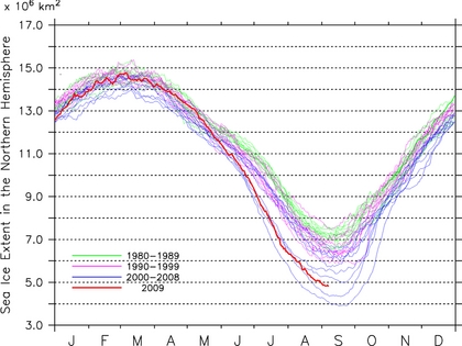
Figure 3. Sea Ice extent (click to enlarge)
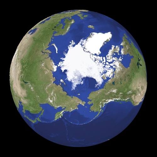
Figure 4. Satellite imagery of Arctic region (click to enlarge)
Figure 3 shows that the sea ice extent for the Northern Hemisphere is recorded to be the third lowest ever recorded within historical records. The North Western passage is also recorded to be the third lowest sea ice extent, but the North Eastern passage is recorded to be the 3-4th lowest in recorded history. Figure 4. shows the extent of ice over the Arctic region the current extent is only 4.8 million km2.
Sea Ice Conditions along Polar Routes
| NW Passage |
| Gulf of St.Lawrence |
Grand Banks |
Labrador Sea |
Davis Strait |
Baffin Bay |
Canadian Arctic E |
Canadian Arctic W |
Beaufort region |
Chukchi | Bering West |
| IF | IF | IF | IF | IF | IF | IF | IF | IF | |
| Greenland Sea SW |
Foxe Basin |
||||||||
| IF |
| NE Passage |
| Bering West |
Chukchi | East Siberian |
Laptev | Kara Sea N |
Barents Sea NE |
Barents Sea S |
Barents Sea NW |
| IF | IF | IF | IF | IF | IF | IF | |
| Kara Sea S |
|||||||
| IF |
| Ice Concentration | Passage situation | |
| equal or more than 7 |
ships can not sail without icebreaker | |
| 4-6 | ice-strengthend ships can sail | |
| less than 3 | ice-worthy ships can sail | |
| IF | Ice Free | normal ships can sail |
Table. Sea ice extent for each region in the Arctic, showing the labelled colors to indicate navigable routes around the North Eastern and North Western passages.
The North Eastern and North Western passages remain closed for the time being although there is a slight expectation that both passages may finally shed its icy cover and open for shipping next week. The North Western passage, Within the Canadian Arctic West, finally shows positive signs of retreat, as ice around Somerset Island continues to melt now at just 1-2/10th around the coast of the island, making this area open for ice worthy ships, although future melting is needed for this route to become completely usable. Melting has also continued to occur within Foxe Basin, where sea ice has now cleared except for a small area around the Prince Charles Island, which has a concentration of 3/10th. Although caution is still needed within this area as many coastal areas are still subject to 1/10th sea ice. The North Eastern passage is still only hindered at the Taimyr peninsula. Within the Laptev sea, around the coast of Severnaya Zemlya, sea ice of only 7-8/10th's blocks the passage, however this area has shown a decrease in sea ice throughout the past week and as a result sea ice within the Kara Sea North Has now completely cleared. There is now an expectation that the area may clear this week. All other areas within the North Eastern passage remain clear to vessels.
Model Prediction
Weathernews's I-SEE engine indicates that sea ice movement is set to change from migrating towards the Taimyr peninsula, it now appear that ice is set to move towards the Greenland Sea, this will result in an accumulation of sea ice within this area, this pattern is set to continue throughout the month, although low pressure systems within the East Siberian Sea will result in the sea ice once again moving towards the Taimyr peninsula for short periods. The I-SEE model also predicts that there will be a slight increase in sea ice extent due to the low temperatures predicted by the Global Forecast Model, which will promote freezing in areas. From this we can conclude that by the end of September the melting period will be over.
Note-The Weathernews I-SEE engine indicates that both passage are already open although it is clear that this is not the case, this is because this models initial conditions are based on AMSR-E satellite data which is known to have a problem identifying ice formations near the edge of the ice.
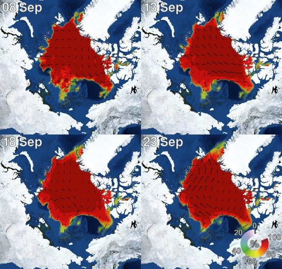
Figure 5. I-SEE engine, model predictions of the arctic sea ice.