
2009.09.22
GIC Weekly Report for the Arctic Region Vol.8
The Global Ice Center's 'Arctic ice watch' comes to an end as freezing progressing
Topic of the Week
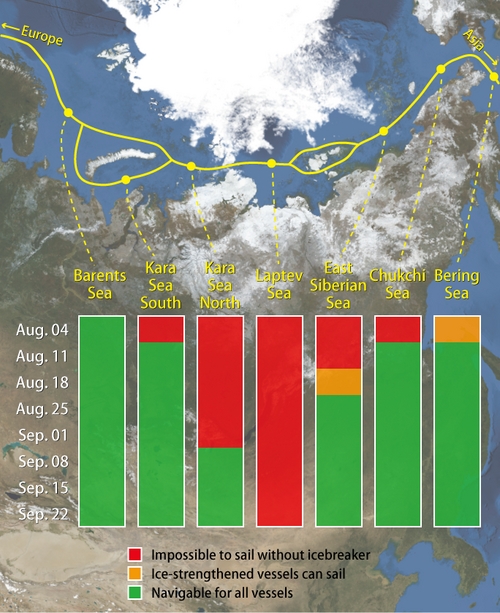
Figure 1. Sea ice condition along the North Eastern passage for this summer (click to enlarge)
The North Eastern and North Western Passages will remain closed for the year now, as temperatures have shown signs of the winter seasonal freezing. The North Western passage is still only blocked at the Canadian Arctic West, sea ice around this region has continued to decrease throughout the season from fast ice in early August to just 1-3/10th between the Prince Of Wales island and Somerset island, although ice has started to accumulate to the north of the island meaning that the winter freezing period is upon us within this passage. The North Eastern passage has also began to show signs of the winter freezing period, with sea ice extent starting to increase (figure 2). The only area blocking this passage in to date is the sea ice around the Severnya Zemlya and its adjacent islands, however this area has thick first year ice being in the concentration of 9-10/10th, this has shown to have only slightly decreased throughout the whole melting period.
Figure 1 shows the route a vessel would take around the North Eastern passage, below this, the graphics describe the sea ice situation from August to the end of September. It can be seen that the least melting occurred within the Laptev Sea, as this area still remains closed. The Barents Sea, Chukchi Sea and the Bering Sea are all situated to the edge of the eurasian continent. Figure 1 shows that these areas experienced ice loss before any other areas as the migration of Pacific and Atlantic water moved north into the arctic region. The Kara Sea South also melted early in the year on the 11th August. Within the Kara Sea South lies the delta of the river Ob, this brings warmer and fresher water to this region and may have promoted the melting period. An analysis of air temperature over the season has show that the North Eastern passage was cooler than average, although, the North Western passage was warmer than average. These findings agree with what is expected of air temperature trends on an El Niño year.
Sea Ice Extent
|
Arctic Western Arctic Eastern Arctic |
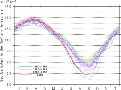
Figure 2. Sea ice extent of the entire Arctic, western Arctic and eastern Arctic. (click to enlarge)
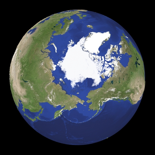
Figure 3. Satellite imagery of Arctic region. (click to enlarge)
Figure 2 shows that the sea ice extent for the Northern Hemisphere is recorded to be the third lowest recorded within historical records. The North Western and North Eastern passages are recorded to be the third lowest sea ice extent. Both passages have now entered the winter freezing season, the North Eastern passage's increase in sea ice has started at roughly the same time as previous years although the current weather analysis shows that temperatures are still fairly high within this region suggesting a slower increase in sea ice in 2009. Figure 3 shows the extent of ice over the Arctic region the current extent is only 4.98 million km2.
Sea Ice Conditions along Polar Routes
| NW Passage |
| Gulf of St.Lawrence |
Grand Banks |
Labrador Sea |
Davis Strait |
Baffin Bay |
Canadian Arctic E |
Canadian Arctic W |
Beaufort region |
Chukchi | Bering West |
| IF | IF | IF | IF | IF | IF | IF | IF | IF | |
| Greenland Sea SW |
Foxe Basin |
||||||||
| IF |
| NE Passage |
| Bering West |
Chukchi | East Siberian |
Laptev | Kara Sea N |
Barents Sea NE |
Barents Sea S |
Barents Sea NW |
| IF | IF | IF | IF | IF | IF | IF | |
| Kara Sea S |
|||||||
| IF |
| Ice Concentration | Passage situation | |
| equal or more than 7 |
ships can not sail without icebreaker | |
| 4-6 | ice-strengthend ships can sail | |
| less than 3 | ice-worthy ships can sail | |
| IF | Ice Free | normal ships can sail |
Table. Sea ice extent for each region in the Arctic, showing the labelled colors to indicate navigable routes around the North Eastern and North Western passages.
The North Western passage and the North Eastern passages remain closed for the final report of the season, as temperatures have started to decline once again for the winter season. The Canadian Arctic West is still the only area blocking the opening of the North Western passage. As sea ice to the north east of the Prince Of Wales island has increased to 1-3/10th's over the last week, sea ice to the south of the island is still present but slowly showing a decrease. Sea ice within the Chukchi Sea has increased over the last week and will soon block the passage for the winter season near Verkhniy Lildin Island. All other areas in the North Western passage remain open.
The North Eastern passage continues to stay closed at the Taimyr peninsula with persistent ice, around the Severnaya Zemyla and its adjacent islands, although there seems to be a slight decrease in sea ice around this region it is clear that this passage will not be supporting vessels in 2009.
Model Prediction
The Weathernews I-SEE engine (Figure 4) indicates that ice will migrate to both the Greenland Sea and the Chukchi Sea, with freezing also occurring in these areas due to the low temperatures. Within October this pattern will continue with less ice migration leaving any growth of the sea ice up to freezing. The Global Forecasting Model shows that over the next week the North Eastern passage will continue to remain cold, with temperatures ranging from 0 to -5°C. This is due to warmer air moving up to the region from temperate climates. On the North Western passage temperatures will range between -5°C and -10°C, as high-pressure pressure systems move over the area from the North East, leaving clearer skies and promoting colder weather and eventually freezing of the water.
Note-The Weathernews I-SEE engine indicates that both passage are already open although it is clear that this is not the case, this is because this models initial conditions are based on AMSR-E satellite data which is known to have a problem identifying ice formations near the edge of the ice.
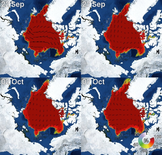
Figure 4. I-SEE engine, model predictions of Arctic sea ice.