
2010.08.06
GIC Weekly Report Vol.1
The North Western Passage has a big chance to open in this summer.
Topic of the Week
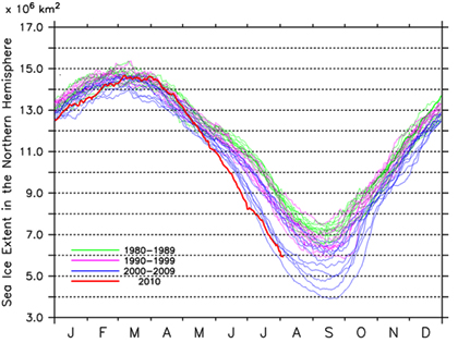
Based on analysis of satellite imagery, sea ice extent in the Arctic Ocean has been showing a substantial decrease in this summer season as seen in recent years. Sea ice extent in the Arctic as of now is estimated to be about 6 million km2, leading it to be the second lowest sea ice extent for this time of year in recorded history. This trend of substantially low sea ice coverage during summer season agrees with what has been observed in this decade, following a long-term trend of decline of minimum sea ice extent seen for several decades.
Meteorological factors have played a role in the present sea ice condition. Data showed that a high pressure system dominated over the Beaufort Sea from May to June 2010. It seemed to generate an effect of outflow of sea ice from the Arctic through the Greenland Sea, resulting in slightly less sea ice than the previous summer in the western part of the Arctic region, particularly in coastal areas of the Canadian Arctic Archipelago. On the other hand, the sea ice extent in the eastern part of the Arctic has been observed to stay at a level similar to the previous season. The sea ice extent in the western part of the Laptev Sea, however, is slightly larger. The current condition of the sea ice extent is indeed supported by a simulation study based on satellite data during the previous winter season.
As the Arctic sea ice is expected to continue to decrease towards its minimum extent, which normally occurs between late August and early September, there are possibilities for polar routes to open during this summer. The North Western Passage, in particular, has a big chance.
Sea Ice Extent
|
Arctic Western Arctic Eastern Arctic |
Figure 1. Sea ice extent of the entire Arctic, western Arctic and eastern Arctic. (click to enlarge)
Figure 2. Satellite imagery of Arctic sea ice. (click to enlarge)
The current sea ice extent in the Arctic area has been shown to be at the second lowest level for this time of the season in recorded history. Although decrease of sea ice has somewhat subsided since July, which might be associated with a decay of the dominating high pressure over the Beaufort Sea, it still tracks towards the second lowest minimum sea ice extent following the lowest occurrence in summer 2007.
The present ice distribution is in agreement with the simulation study based on observed satellite data during the previous winter season.
A noteworthy feature in the present sea ice condition is discernibly less sea ice than the previous season over coastal areas of the Canadian Arctic Archipelago, which includes Banks Island, Victoria Island, Queen Elizabeth Islands, Ellesmere Island, and Baffin Island. In the eastern Arctic region, sea ice extent as a whole appears to be similar to what was in the previous summer. Of particular interest is that slightly thicker sea ice has remained in the western part of the Laptev Sea.
Sea Ice Conditions along Polar Routes
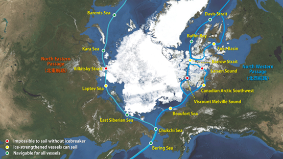
Figure 3. Sea ice condition around the North Eastern and North Western passages.
Figure 3 illustrates the present condition of sea ice distribution and polar routes in the Arctic Ocean. Considering the remarkable speed of sea ice decline currently observed, there are possibilities to see routes open during this summer season. Looking back to conditions in recent years, several passages have opened. In 2005 the North Eastern Passage opened, commonly regarded as the first case of a polar route. In summer 2007, the significant decline of sea ice extent resulted in the opening of the North Western Passage for the first time. In summer 2008, both of the passages opened finally. In 2009, however, neither of the passages had opened throughout the summer season. Reasons of the result were firstly, despite its relatively higher than average temperature in recent years as a whole, sea ice melting slowed during a period between late July and early August. Secondly, the outflow effect of atmospheric circulation for sea ice from the Arctic to the Atlantic was less than expected, resulting in remaining sea ice over the Canadian Arctic Archipelago. Thus, the overall trend indeed has not been clear yet. However, considering the current situation particularly across the coastlines of the Canadian Arctic Archipelago, there is a possibility for the North Western Passage to open sometime during this season. As for the North Eastern Passage, the sea ice condition in the western part of the Laptev Sea, where sea ice still covers the coastlines of the Vilkitsky Strait, will be a key for the opening this summer. A swell of sea ice extent in the Eastern Siberian Sea is forecast to gradually fade away towards the peak period, as has been observed in recent years, allowing the route to be open along the coastlines.
Model Prediction
Figure 4 illustrates a forecast of sea ice extent in August 2010, derived from 'I-SEE engine', Weathernews' original sea ice forecast model. It suggests pronounced reductions of ice coverages in the western Laptev Sea and the Canadian Arctic Archipelago.
An observational data has shown that, since late July, a high-pressure has emerged over the Beaufort Sea again, driving the clockwise flow of sea ice and consequent outflow in the Arctic. If the system continues to dominate over the region in August, the reduction of sea ice extent could become accelerated once again because of the mechanism of the sea ice outflow. This phenomenon is indeed reproduced in the model prediction (top left panel). However, the model suggests a trend of counter-clockwise sea ice rotation in late August (bottom panels). In either case, the model prediction still suggests very little sea ice extent in the Canadian islands in late August.
In conclusion, it seems highly likely that the rapid decline will eventually promote the opening of the North Western Passage.
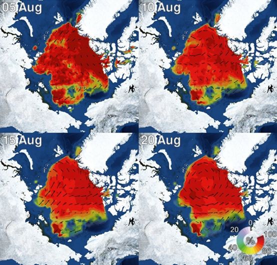
Figure 4. I-SEE engine model predictions of Arctic sea ice