
2010.09.02
GIC Weekly Report Vol.5
Northwestern Passage nearly open.
Topic of the Week
The Arctic sea ice has continued to decrease throughout this week, approaching its minimum extent in this summer season. The upcoming 2010 minimum sea ice extent is forecast to be the second or the third lowest in recorded history.
This summer, the western Arctic has shown a significant ice melting, and the current sea ice conditions, particularly, across the Canadian Arctic Archipelago, provide a chance of opening the Northwestern Passage in this season. Most part of the southern route is now clear of ice, and the route is only hindered by icy areas in Peel Sound and Barrow Strait. Although the passage is not yet fully open, depending on the circumstances over the next few days, it is highly likely to open sometime in early September.
In the eastern Arctic, although the sea ice has continued to decline throughout this week, some amount of sea ice still persist over several key areas such as coastal areas of the Vilkitsky Strait and its vicinity. Although the passage is not totally ice-free, it is in fact half-open already. It is reported that, a commercial tanker accompanied by nuclear powered ice breakers has begun its voyage from a port in northwestern Russian to a port in China sailing along Russian Arctic coast, and has successfully navigated through the hardest part in the planned route.
Our forecast suggests that the Arctic sea ice will soon show its minimum extent, and then the seasonal freezing will begin sometime in mid-September. In terms of the possibility of navigable polar routes in this season, it is worth keeping an eye on the Arctic sea ice change over the next two weeks.
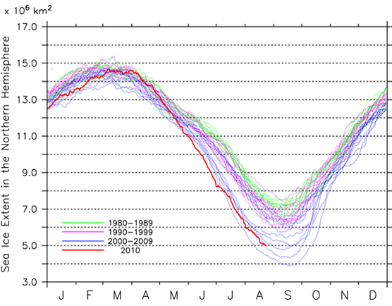
Sea Ice Extent
|
Arctic Western Arctic Eastern Arctic |
Figure 1a-1c. Sea ice extent of the entire Arctic(1a), western Arctic(1b), and eastern Arctic(1c)
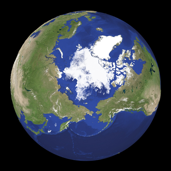
Figure 2. Satellite imagery of Arctic sea ice.
Similar to the previous period, Arctic sea ice has continued melting throughout this week. Figure 1a illustrates the change in the Arctict sea ice extent. The present Arctic sea ice extent as a whole is estimated to be approx. 4.8 million square kilometers. This is the third lowest extent for this time of the season after the lowest extent of 4.3 million square kilometers in 2007 and the second lowest of 4.6 million square kilometers in 2008. As the Arctic sea ice is approaching its minimum extent, sea ice melting has gradually slowed down. The minimum is most likely to occur within a few weeks.
The sea ice in the western Arctic has shown a continuous melting, and the current extent is at the second lowest level in the record (Figure 1b). In contract, melting rate in the eastern Arctic has notably eased up this week and, consequently, the sea ice extent of the area appears to be almost in a level of this year’s minimum extent (Figure 1c).
Figure 2 shows a snapshot of the current sea ice distribution in the entire Arctic based on passive microwave satellite imagery. The figure suggests that sea ice melting has been still remarkable in the western Arctic, and sea ice concentration across the coasts of the Canadian Arctic Archipelago has become considerably low over the past week. In addition, the map clearly shows that sea ice in the eastern Arctic, especially over the western Laptev Sea and coastal areas of the Vilkitsky Strait, has notably retreated, leaving only somewhat scattered sea ice.
Sea Ice Conditions along Polar Routes
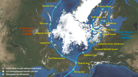
Figure 3. Sea ice condition around the North Eastern and North Western passages.
Figure 3 illustrates the present conditions of the polar routes in the Arctic Ocean. Substantial ice melting along the southern route of the Northwestern Passage has made the passage nearly open.
Our analysis based on satellite data suggests that a route through the south of King Williams Island has been clear of ice. Since there are still some residual sea ice extents in Peel Sound and Barrow Strait, the shipping lane is not yet completely open. Considering the current trend of the sea ice decline over the region, the passage is increasingly likely to open sometime soon during this season.
In the eastern Arctic, the chance for the Northeastern Passage to open has been increasing thanks to the notable melting seen in the Laptev Sea.
Model Prediction
Figure 4 shows the forecast of the Arctic sea ice in 2 to 17 September based on model predictions done by our original simulator, Weathernews’ “I-SEE Engine”, showing a sign of the end of melting season. The figure illustrates that Arctic sea ice extent will continue to decline early in the forecast period. Later in the period, for example, a slight decrease of the sea ice concentration in the north of Svalbard, and a discernible expansion of sea ice coverage in the east of Severnaya Zemlya are forecast (right-bottom panel).
The model prediction, therefore, suggests that the upcoming 2010 sea ice minimum will probably occur within the forecast period, and the winter seasonal freezing will begin shortly afterward.
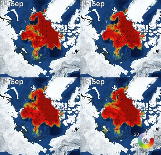
Figure 4. I-SEE engine model predictions of Arctic sea ice.