
2010.09.09
GIC Weekly Report Vol.6
The Northwestern Passage is finally open now.
Topic of the Week
The Arctic sea ice has continued to decrease this week, and the substantial ice melt so far observed across the Canadian Islands finally results in a southern route in the Northwestern Passage being opened (Figure 1). The opening of the NW Passage is for the first time in two years since summer 2008. Sea ice extent has continued to fall also in the eastern Arctic. An extended area with relatively low ice concentration around the Vilkitsky Strait will be a key for the opening of the Northeastern Passage in this summer. The Arctic sea ice extent is expected to reach the seasonal minimum sometime in the next couple of weeks, and the minimum extent will last for several weeks, during which the polar routes are most likely to become navigable. The winter seasonal freezing will begin shortly afterwards, closing the polar routes until the next summer.
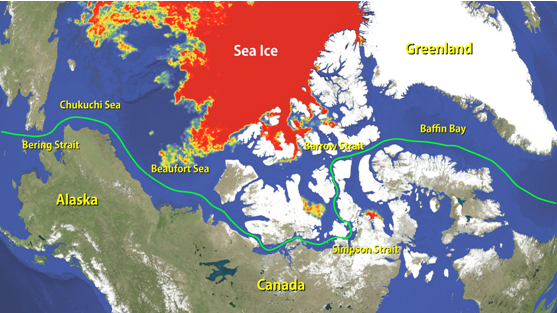
Figure 1. Southern route of Northwestern passage, which opened this month.
Sea Ice Extent
|
Arctic Western Arctic Eastern Arctic |
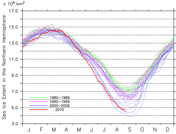
Figure 2a-2c. Sea ice extent of the entire Arctic(2a), western Arctic(2b), and eastern Arctic(2c)
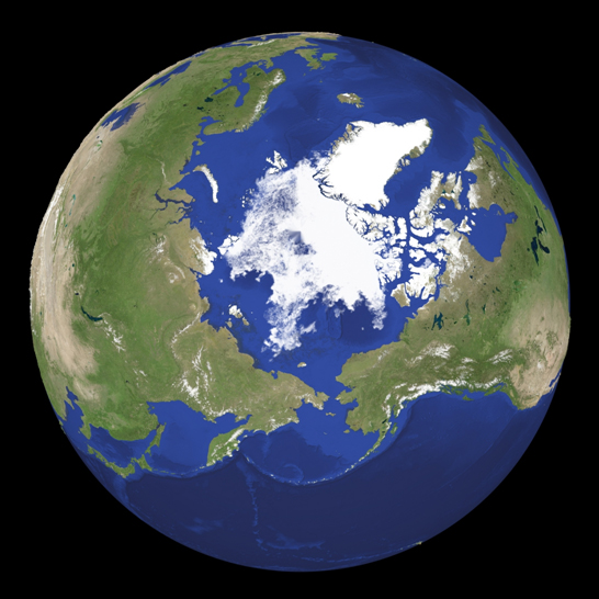
Figure 3. Satellite imagery of Arctic sea ice.
The sea ice extent in the entire Arctic as of 8 September 2010 is estimated to be approx. 4.5 million square kilometers, the third lowest on record for the time of year after the lowest in 2007 and the second lowest in 2008 (Figure 2a). The sea ice extent in the western Arctic is about 2.4 million square kilometers, being the second lowest extent following the lowest extent of 2.3 million square kilometers in summer 2008 (Figure 2b). The extent in the eastern Arctic is about 2.1 million square kilometers, which is within the normal range observed in recent years (Figure 2c). The sea ice melt in the Arctic will gradually slow down towards the minimum ice extent, which will probably occur in a few weeks, and subsequently, the seasonal freezing is expected to begin. Figure 3 shows a snapshot of the current Arctic sea ice distribution based on passive microwave satellite imagery. Sea ice particularly across the Canadian Island has largely melted out over the past few weeks, leaving only some extended areas of thin sea ice. In the eastern Arctic, sea ice concentrations across the coastal areas of the East Siberian Sea have fairly fallen over the past week.
Sea Ice Conditions along Polar Routes
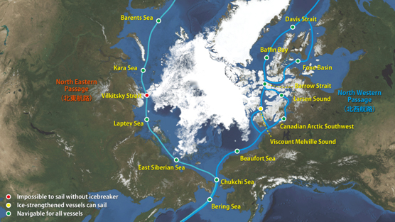
Figure 4. Sea ice condition around the North Eastern and North Western passages.
The continuous melting of sea ice in the western Arctic finally opened the Northwestern Passage. Figure 4 illustrates the present conditions of the western and eastern polar routes in the Arctic on top of the satellite imagery. As the sea ice melt has continued across the Canadian Islands, some residual sea ice located in Peel Sound and Barrow Strait largely melted out. Consequently, a south route passing through the south of King William Island in the NW passage become navigable now. The north route, on the other hand, is not yet completely open because of some scattered icy areas located across Viscount Melville Sound and Barrow Strait. As the sea ice extent in the Arctic is expected to reach its annual minimum sometime soon, and the very-low sea ice coverage in the region will last for several more weeks, the south route will potentially remain open for a while. In the eastern Arctic, in spite of the continuous sea ice retreat observed throughout this summer, the Northeastern Passage is not yet fully open due to some extended sea ice still residing around the Vilkitsky Strait. As the melting proceeds, the passage will potentially open sometime in late September.
Model Prediction
Figure 5 shows the forecast of the sea ice distribution in the entire Arctic in 9 to 24 September based on our model prediction done by Weathernews' "I-SEE Engine". As the Arctic sea ice extent is already near the bottom for this summer season, the change in sea ice distribution will likely to become somewhat moderate compared to that in early stage of the season. The Arctic sea ice is forecast to continue melting over the next couple of weeks, approaching the 2010 minimum extent. Later in September, the winter freezing in the Arctic will then begin. The freezing of sea ice will start around the north pole, and progress towards lower latitude. The Northwestern Passage is forecast to close again by the end of September.
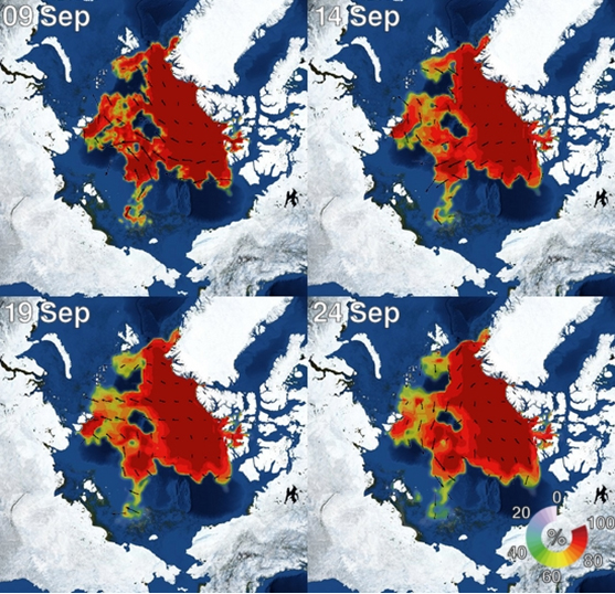
Figure 5. I-SEE engine model predictions of Arctic sea ice.