
2010.09.16
GIC Weekly Report Vol.7
Northwest Passage remains open; Northeast Passage nearly opens.
Topic of the Week
As reported in the previous issue, the Northwestern Passage was finally open last week, and the passage had remained fully open until 10 September (figure 1). Although the passage was once blocked by some scattered sea ice blown back to the coastal areas of Barrow Strait by westerly winds, it is now open again. The wind direction over the region will play an important role in the sea ice conditions along the passage for some time to come. Dominant easterly winds over the area are forecast to persist for a couple of days, potentially pushing sea ice away and consequently allowing the route remain open. The wind is then forecast to turn westerly, and thus sea ice will be pulled back to the area, closing the passage. In the eastern Arctic, the sea ice around the Vilkitsky Strait has continued to decrease. Consequently, the passage is now nearly open. If the ice melt lasts for several more days, the passage may briefly become navigable within the time of the minimum ice extent. The Arctic sea ice as a whole is about to reach the seasonal minimum extent. The winter freezing will then begin shortly afterwards. The upcoming 2010 sea ice minimum is expected to end up with the third lowest extent in recorded history.
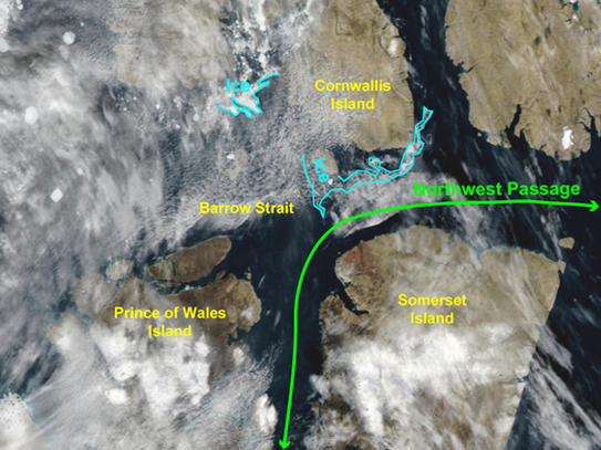
Figure 1. Ice distribution in the Barrow Strait(74oN, 98oW) on 10 September. Derived from Terra/MODIS satellite image. Green line shows the Northwest Passage.
Sea Ice Extent
|
Arctic Western Arctic Eastern Arctic |
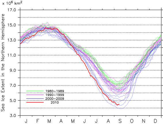
Figure 2a-2c. Sea ice extent of the entire Arctic(2a), western Arctic(2b), and eastern Arctic(2c)
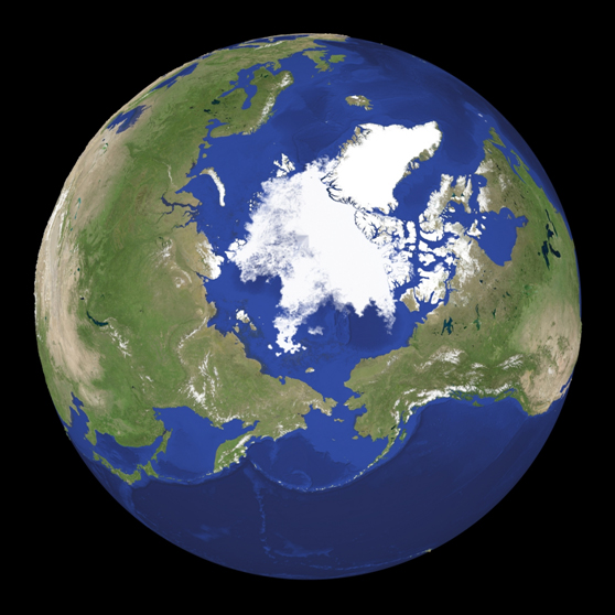
Figure 3. Satellite imagery of Arctic sea ice.
Figure 2a shows the change in sea ice extent in the entire Arctic. The Arctic sea ice extent as of 14 September is estimated to be approx. 4.5 million square kilometers, the third lowest extent in the satellite record after the lowest extent of 4.0 million square kilometers in 2007 and the second lowest extent of 4.4 million square kilometers in 2008. As seen in the plot, the Arctic sea ice is already its minimum extent with probably one to two weeks left in this summer season. The current sea ice extent in the western Arctic is approx. 2.4 million square kilometers, which is actually at its lowest-ever in recorded history followed by the second lowest occurred in 2008 (figure 2b). The plot suggests that sea ice in the western Arctic is already at the seasonal minimum, and there is indeed a sign of the winter seasonal freezing. The sea ice extent in the eastern Arctic as of now is approx. 2.1 million square kilometers. As seen in figure 2c, the sea ice in the area has continued to decrease with keeping its decline speed over the past few weeks. The sea ice in the area is expected to reach its annual minimum extent sometime soon. Figure 3 shows a snapshot of the current Arctic sea ice distribution derived from passive microwave satellite imagery. The map shows the Arctic sea ice discernibly thicker than that in the previous period, suggesting that the seasonal melting has almost ended, and the winter freezing will soon start in the Arctic Ocean.
Sea Ice Conditions along Polar Routes
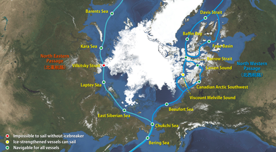
Figure 4. Sea ice condition around the North Eastern and North Western passages.
Figure 4 illustrates the present conditions of polar routes on top of the satellite imagery. Our analysis of satellite data suggests that the ice-free area in the southern route of the Northwestern Passage, which was largely open and thus navigable last week, has become slightly narrower because of some remaining sea ice in Barrow Strait. As such thin sea ice easily moves back and forth under the influence of the wind and current across the region, how long the route stays open will strongly depend on meteorological conditions. Continuing from last week's conditions, the north route of the Northwestern passage has been hindered by several remaining sea ice residing across Viscount Melville Sound. As for the Northeastern Passage, none of the shipping lanes are yet fully open due mainly to some scattered sea ice along the Vilkitsky Strait. As the sea ice in the area is forecast to continue to decrease through this week, it is still possible for the passage to open by the end of this melting season.
Model Prediction
Figure 5 illustrates the forecast of the Arctic sea ice in 16 September to 1 October based on predictions done by Weathernews' “I-SEE Engine”. The model output suggests that the Arctic sea ice nearly reached its annual minimum extent already. The winter seasonal freezing is expected to begin in the next couple of weeks, and the Arctic sea ice will start to gradually expand from the North Pole toward lower latitude in the region. In the western Arctic, the remaining sea ice in Barrow Strait will be the key for the opening of the Northwestern Passage within the rest of the melting season. Dominant easterly winds over the area are forecast to persist until 17 September, allowing the route stay ice free for several more days. The wind will then turn westerly, most likely closing the sailing route. In the eastern Arctic, the sea ice is forecast to continue to decrease over the next week, still leaving a chance for opening the Northeastern Passage. The winter freezing is then forecast to begin in the coastal areas of Siberia by the end of September.
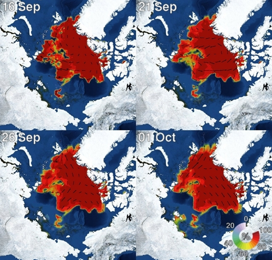
Figure 5. I-SEE engine model predictions of Arctic sea ice.