
2010.09.24
GIC Weekly Report Vol.8
Northwest/Northeast Passages are now both open
Topic of the Week
Continuing from the previous period, the southern route of the Northwestern Passage has still remained open, and the condition has become slightly better because of continued melting in several key areas along the route.
Additionally, based on analysis of satellite imagery, the Northeastern Passage has been confirmed to be presently navigable as a consequence of continuous melting of remaining sea ice around the Vilkitsky Strait over the past few weeks (figure 1).
Thus, both of the NW/NE passages are currently open. The occurrence of the simultaneous opening of the two passages is the first time in two years since summer 2008. This circumstance, however, is expected to end soon, as the annual freeze-up of sea ice has just begun on both sides of the Arctic Ocean. The polar routes will be closed again sometime in late September or early October.
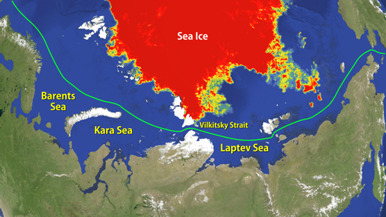
Figure 1. Northeastern passage and current sea ice distribution near the passage
Sea Ice Extent
|
Arctic Western Arctic Eastern Arctic |
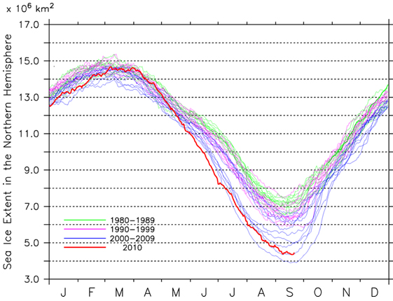
Figure 2a-2c. Sea ice extent of the entire Arctic(2a), western Arctic(2b), and eastern Arctic(2c)
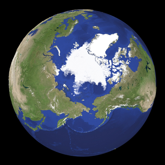
Figure 3. Satellite imagery of Arctic sea ice.
Figure 2a illustrates the daily sea ice extent in the entire Arctic, along with sea ice extent curves observed for the past 30 years. The Arctic sea ice extent as of 21 September is approximately 4.5 million square kilometers. The 2010 minimum extent was about 4.4 million square kilometers, which was the third-lowest extent in the satellite record after 2007 and 2008.
The sea ice in the western Arctic ended up with the record low minimum extent of 2.3 million square kilometers. The current ice extent in the area is approximately 2.5 million square kilometers, meaning that sea ice extent has already started to increase due to the seasonal expansion (figure 2b).
The sea ice extent in the eastern Arctic is now in the seasonal minimum with an estimated value of about 2.0 million square kilometers, the third or fourth lowest extent on record (figure 2c).
Figure 3 shows a snapshot of the current sea ice conditions in the northern hemisphere derived based on passive microwave satellite imagery.
Satellite imagery suggests that, although sea ice in low-latitude Arctic has declined over the past week, there are discernible signs of onset of sea ice freezing in high-latitude Arctic. A trend in recent years suggests that, after the remarkable ice retreat as seen in this summer season, a relatively steep increase of sea ice extent due to rapid freezing is expected to occur over the next month.
Sea Ice Conditions along Polar Routes
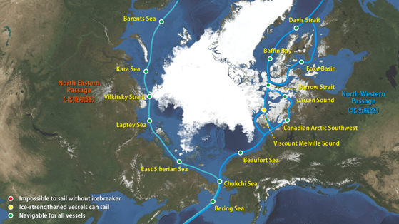
Figure 4. Sea ice condition around the North Eastern and North Western passages.
Figure 4 illustrates the current conditions of the Arctic sea routes on top of the satellite imagery. In the eastern Arctic, sea ice at the mouth of the Vilkitsky Strait has continued to decrease over the past week, and consequently, the Northeastern Passage appears to be clear of ice now. Continuing from last week, the southern route of the Northwestern Passage is still open. While the north route of the passage is still hindered by some remaining sea ice in Viscount Melville Sound and thus not yet navigable.
Thus, currently both of the Arctic sea routes are navigable, and the occurrence of the simultaneous opening is the first time in two years since summer 2008.
As satellite imagery clearly shows that the winter seasonal freezing has already begun in the Arctic Ocean, both of the passages will be closed sometime in the next couple of weeks.
Model Prediction
Figure 5 shows the forecast of the Arctic sea ice distribution in 23 September to 8 October based on our model prediction done by Weathernews' "I-SEE Engine". The output suggests that the Arctic sea ice is now in the transition to its annual cycle of growth, and the sea ice extent will begin to gradually increase during the forecast period.
Of particular interest is the indication of a rapid new ice formation in coastal areas of Siberia later in the forecast period. Although there is still a possibility of an overestimation in the model prediction, the fast growth of sea ice in the area may be due in part to the fact that ocean along the coastal areas of Siberia is relatively shallow and thus prone to freeze up.
The main body of the Arctic sea ice around the North Pole will gradually expand towards lower latitude over the next several months, and most part of the Arctic Ocean will eventually be covered by sea ice in mid-winter.
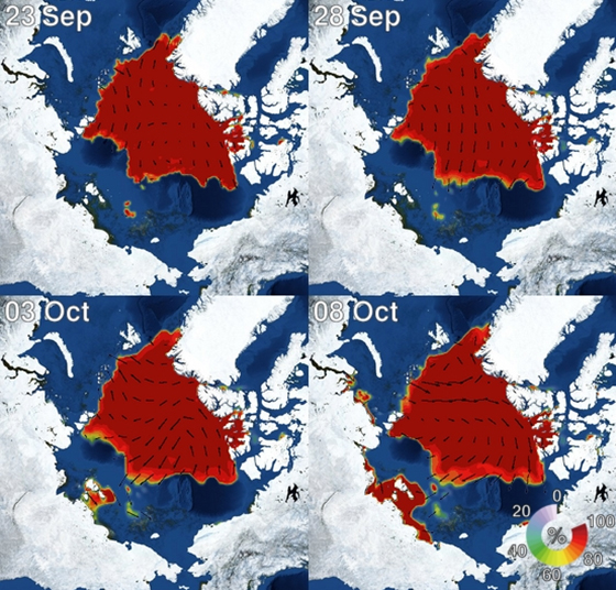
Figure 5. I-SEE engine model predictions of Arctic sea ice.