
2010.10.07
GIC Weekly Report Vol.10
Rapidly spreading Arctic sea ice closes the Polar Routes.
(This is the final report for this season.)
Topic of the Week
In the Arctic Ocean, the annual cycle of sea ice growth has already begun, and sea ice is now rapidly expanding across the entire Arctic. Based on analysis of satellite imagery, both of the Northwestern and Northeastern Passages have just closed by new ice emerging across several key areas along the sailing routes. Figure 1 illustrates the Arctic sea ice at its annual minimum overlaid onto the state in summer 2000. Of particular interest is this year's significant ice decline in places along shores of the Canadian Arctic Archipelago and off the East Siberian Sea. This phenomenon of significant ice loss in those regions is indeed a trend seen notably in recent years. This summer the Arctic sea ice reached the third-lowest minimum extent in recorded history, after the lowest in 2007 and the second-lowest in 2008. The minimum extent which occurred on 9 September was about 4.5 million square kilometers. In particular, the western Arctic experienced remarkable ice loss with its minimum extent momentarily dropping to the lowest-ever level in mid-September. Consequently, the Northwestern Passages became navigable in early September. In mid-September, remaining sea ice along the Vilkitsky Strait was found to be largely melted away, resulting in the opening of the Northeastern Passage. The occurrence of the simultaneous opening of the two passages is the first time in two years since summer 2008. Ultimately, the NW Passages remained navigable for more than 3 weeks, and the NE passage for about 2 weeks during this summer season. As the polar routes are expected to stay closed during the winter season, this report will most likely be the final report for this season. The GIC Weekly Report will start again at the beginning of summer 2011 for providing a variety of information about the Arctic sea ice and polar routes.
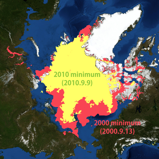
Figure 1. Minimum sea ice extent in this summer, compared with minimum in 2000
Sea Ice Extent
|
Arctic Western Arctic Eastern Arctic |
Figure 2a-2c. Sea ice extent of the entire Arctic(2a), western Arctic(2b), and eastern Arctic(2c)
Figure 3. Satellite imagery of Arctic sea ice
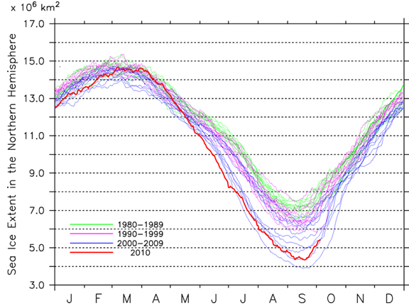
The graph in figure 2a illustrates the daily sea ice extent in the entire Arctic along with the extent observed for the past thirty years. The combined Arctic sea ice extent as of 7 October is estimated to be approx. 5.4 million square kilometers; an increase of 0.4 million square kilometers over the past week. The current sea ice extent in the Western and Eastern Arctic regions are approximately 3.1 million square kilometers and 2.3 million square kilometers, respectively, as shown in figure 2b and 2c.
Figure 3 depicts the current sea ice distribution in the Arctic based on microwave satellite imagery. Compared to last week's conditions, there are discernible increases in the sea ice coverage over the Canadian Arctic Archipelago, particularly along coastlines of the M'Clure Strait and Viscount Melville Sound. As for the eastern Arctic, sea ice has shown clear increases in places along Russian coastal areas, such as in the East Siberian Sea, the Laptev Sea, and the Kara Sea over the past week.
Sea Ice Conditions along Polar Routes
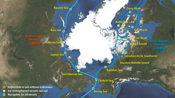
Figure 4. Sea ice condition around the North Eastern and North Western passages
Figure 4 illustrates the current state of the polar routes on both sides of the Arctic Ocean. Due to rapidly developing new ice in the entire Arctic seen over the past week, both of the polar routes have just closed again. Around the Canadian Islands, the southern route which had been open for several weeks, is now hindered by patches of new ice emerging over Lancaster Sound and Baffin Bay. Rapid ice formation has been observed in the Barrow Strait, where sea ice concentration has reached 90~100% already. In the eastern Arctic, a rapid growth of ice in the Vilkitsky Strait appeared to close the Northeastern Passage on 3 October.
Model Prediction
Figure 5 shows the forecast of the Arctic sea ice in 7 to 22 October based on model predictions performed by Weathernews' I-SEE Engine. The output suggests that the Arctic sea ice is expected to broadly expand with a rapid pace of freeze-up during the forecast period. Several areas such as the East Siberian Sea, Laptev Sea and the Canadian Islands will experience surges in ice growth over the next several weeks. This appears to be primarily due to a possible presence of a clockwise atmospheric circulation which has been forecast to persist especially during the later half of the period. This type of atmospheric condition over the Arctic is known to accelerate the new ice formation broadly across the East Siberian Sea, Laptev Sea, and Beaufort Sea in the early stage of the winter seasonal freezing.
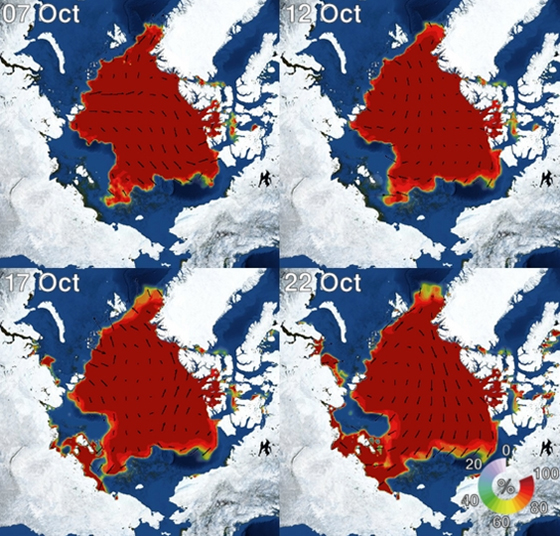
Figure 5. I-SEE engine model predictions of Arctic sea ice