
2011.08.30
2011 GIC Weekly Report Vol.4
Commercial Voyage Through the Northeast Passage Begins!
Topics of the Week
This year, we have already reported the earliest opening in history of the Northeast Passage on August 5th. Now from the end of August, a Japanese vessel will make the Arctic crossing via the Northeast Passage, escorted by icebreakers. Until now, only European commercial tankers have succeeded in making the crossing, but now for the first time in history a Japanese vessel will sail the Northeast Passage. Here at the Global Ice Center, we are providing information on sea ice conditions and the status of the voyage to support this historic effort.
Figure 1 shows the latest weather conditions in the Arctic. Over the last week, the Northeast Passage has seen 10~20 knot winds and 1~2 meter swell in the Barents Sea and East Siberian Sea but the sea ice has not blocked the passage. Relatively mild weather conditions are expected to follow.
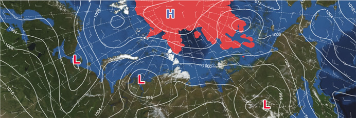
Fig 1: Weather conditions in the Arctic on August 30, 00:00 (UTC)(Click to expand)
The area of sea-ice coverage in the Arctic Sea is expected to continue to recede, with the lowest peak in mid-September. This year, the minimum ice coverage has the potential to be even less than in 2007, and ice is receding at the same pace. Over the next week or two, we will be closely monitoring the state of the sea ice area and voyage on the Northeast Passage.
(*1kt≒0.5m/s)
Sea Ice Extent
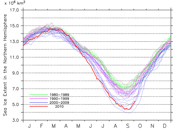
|
Arctic Western Arctic Eastern Arctic |
Figure 2a-2c. Sea ice extent of the entire Arctic(2a), western Arctic(2b), and eastern Arctic(2c).(Click to expand)
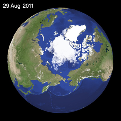
Fig 3: Satellite Generated Image of Sea Ice in the Arctic(Click to expand)
Figure 2 shows the progression of ice in the Arctic Sea. Currently, the ice coverage for the entire Arctic Sea is 4.4 million square kilometers, which is the second smallest area in recorded history (following 4.3 million square kilometers in 2007 during the same period.) The sea ice extent shows a receding trend, receding by another 0.3 million square kilometers last week. Looking at the surface coverage in the western hemisphere (Fig. 2b) and eastern hemisphere (Fig. 2c), we can see that the current 2.5 million square kilometers in the western hemisphere is about the same as levels in 2008 and again in 2010 (approx. 2.4 mil. sq.km.) The eastern hemisphere shows 1.9 million square kilometers, which is the second smallest area recorded, after 1.7 million square kilometers in 2007.
Figure 3 illustrates the current sea ice extent for the Arctic Sea. The right side of the illustration shows sea ice along the Canadian Arctic Archipelago. A large portion of this will melt, and ice concentration will be thin in the remaining areas. This thin ice will spread to many other areas as well. In addition, ice is rotating west (clockwise) around the North Pole, pushing ice southwest into the Beaufort Sea. On the left of the illustration, ice along the Siberian Coast continues to melt in the East Siberian Sea and Laptev Sea.
Sea Ice Conditions along Polar Routes
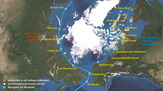
Fig. 4: Sea Ice Conditions along Northeastern/Northwestern passsages
Figure 4 shows the Northeast Passage on the left (Siberian side) and possible opening of the Northwest Passage on the right (Canadian side). There are no major changes in the state of the sailing route, with various openings on the southern route of the Northeastern and Northwestern Passages. Ice continues to melt in the East Siberian Sea and Larsen Sound along the Northeast Passage, with almost no ice remaining. This last week has shown almost no ice blocking the passage. The northern route of the Northwest Passage has some ice in the Viscount Melville Sound which continues to melt, but the thick ice obstructing the passage means that it still cannot be sailed through. The ice in Viscount Melville Sound has hardly melted at all when compared to previous years. The state of this ice is the key factor for the opening in the northern route.
I-SEE Model Predictions
Figure 5 shows the sea ice prediction model output from Weathernews' proprietary I-SEE-Engine for the Arctic Sea. Coming changes in the state of sea predicted are continued gradual receding of the ice that extends out into the East Siberian and Beaufort Sea. Ice in the Arctic Sea is expected to continue to recede until mid-September. We also expect to see the smallest area of ice coverage this year, after which the ice will in all likelihood start to form and extend further out to sea again.
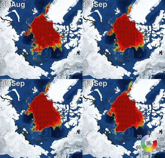
Fig 5: Sea Ice Prediction for the Arctic based on model data