
2011.09.20
2011 GIC Weekly Report Vol.7
Arctic Re-icing Continues
Topics of the Week
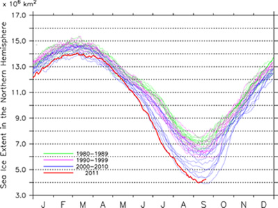
Re-icing is proceeding in the Arctic as a result of falling temperatures, with ice is freezing over rapidly in various areas across the region. As reported last week, this year’s smallest area of ice coverage was 3.97 million km2 recorded in this month. This is the second lowest area recorded since formal observation started in the early 1970s. The lowest area ever recorded was 3.89 million km2, leaving only a small margin between this year and 2007. The northwest and northeast passages currently continue to remain open. However, with the rapid re-icing continuing unabated, the northwestern passage is only expected to be open for no more than another week, while the northeast is expected to close around the end of the month.
Sea Ice Extent
|
Arctic Western Arctic Eastern Arctic |
Fig 1: Arctic Sea Ice Extent(Click to Expand)
(a)Total Arctic Sea Ice Extent (b) Arctic Sea Ice Extent (Western Hemipshere) (c)Arctic (Eastern Hemisphere)
Fig 2: Satellite Generated Image of Sea Ice in the Arctic(Click to expand)
Figure 1 illustrates the progression of the sea ice extent in the Arctic. Looking at this, we can see the change from ice recession to expansion is happening rapidly, and ice is spreading. The current area is 4.3 million km2, which is about 300,000 km2 more than last week. In the Western Hemisphere (Fig. 1b), the ice coverage is 2.6 million km2. In the Eastern Hemisphere (Fig. 1c), it is 1.7 million km2. Both hemispheres show a clear trend towards ice expansion.
Figure 2 illustrates the current sea ice extent in the Arctic Sea. Compared to last week, we can clearly see the ice extent extending in the East Siberian Sea. Also, ice is reaching out again from the Canadian Arctic Archipelago into Larsen Sound. At the same time, there are still some areas at high latitudes where ice has not started to extend outward from the coasts.
Sea Ice Conditions along Polar Routes
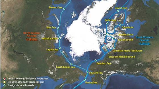
Fig. 3: Sea Ice Conditions along Northeastern/Northwestern passsages
Figure 3 shows possible openings on the northeast (Siberian side) and northwest (Canadian side) of the passage. There are no major changes from last week, and there are still several openings along the southern route of the northeast and northwest passages. However, with icing continuing in the Canadian Arctic Archipelago, the northwestern passage will start to gradually close. In particular, we can see that ice in the Larsen Sound is starting to make the passage narrower than it was in the summer. Additionally, the closing of the northern route of the northwest passage means that there is no longer any possibility of an opening this season thanks to the beginning of closure from increased ice in the Viscount Melville Strait.
I-SEE Model Predictions
Figure 4 is the prediction model output from Weathernews’ I-See Engine. From here on, we expect to see rapid freezing in the Arctic Sea, and ice in the Larsen Sound to obstruct the northwestern passage as early as this week. Also, the model predicts that ice spreading in the East Siberian Sea will close the northeastern passage around the end of September.
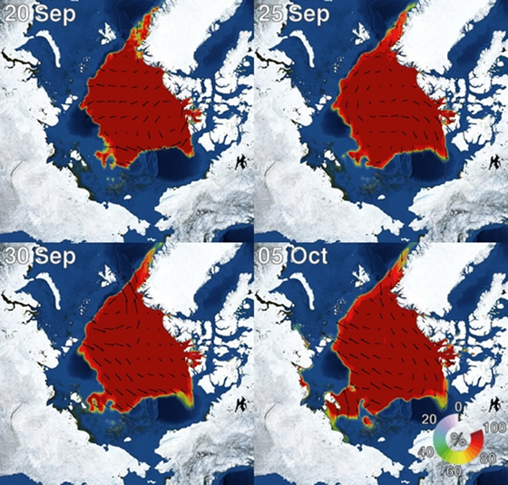
Fig 4: Forecast from Sea Ice Prediction model (Weathernews I-See Engine)