
2011.09.27
2011 GIC Weekly Report Vol.8
Epoch Making Polar Routeing Voyage Concludes Safely
Topics of the Week
Last month, the commercial freighter SANKO Odyssey departed the port of Murmansk for China. Last week, the vessel arrived safely on the 22nd, making her the first Japanese-owned vessel to sail via the Polar Route. The length of this voyage was about 6600 nautical miles, less than half the distance of a typical route via the Suez (approx. 12800nm.) Figure 1 illustrates the vessel’s route through the northeast passage. The red areas in the middle represents concentrated ice that the vessel cannot sail through. The green line shows us how the vessel was able to sail via the Polar Route.
The Arctic has already entered a period of re-icing, and the sea ice extent around the Polar Route is starting to expand. By the end of October, expanding ice is expected to close both passages.
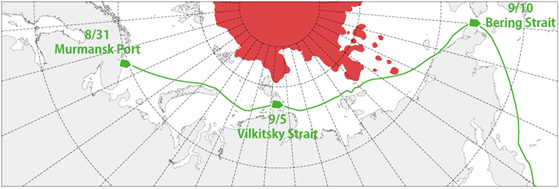 Fig 1: SANKO Odyssey voyage through the Arctic Sea
Red areas represents areas of concentrated ice
Sea Ice Extent
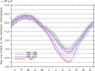
|
Arctic Western Arctic Eastern Arctic |
Fig 2: Arctic Sea Ice Extent(Click to Expand)
(a)Total Arctic Sea Ice Extent (b) Arctic Sea Ice Extent (Western Hemipshere) (c)Arctic (Eastern Hemisphere)
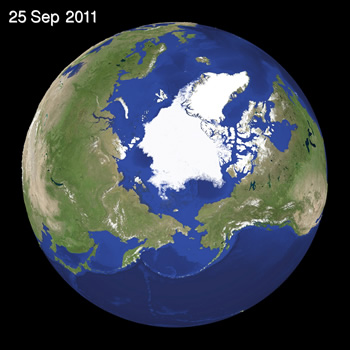
Fig 3: Satellite Generated Image of Sea Ice in the Arctic(Click to expand)
Figure 2 illustrates the progression of the sea ice extent in the Arctic. After reaching the minimum area for the season on the 9th of September, the pattern of melting and receding has shifted to freezing and expanding. The ice coverage on the 26th is 4.6 million km2 greater than on the 9th (4.44 mil.km2). The illustration clearly shows ice expansion in the Western (Fig. 2b) and Eastern (Fig. 2c) areas of the Arctic Sea.
Figure 3 illustrates the latest sea ice extent data on the Arctic Sea as seen by satellite. The satellite imagery confirms this considerably increase of sea ice in the East Siberian Sea and Canadian Arctic Archipelago.
Sea Ice Conditions along Polar Routes
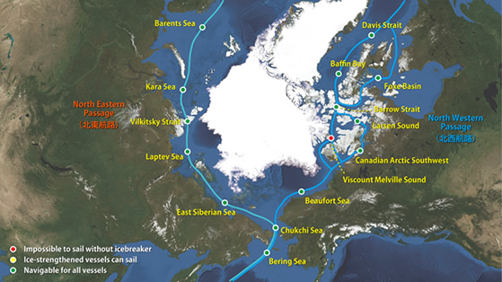
Fig. 4: Sea Ice Conditions along Northeastern/Northwestern passsages
Figure 4 shows open and obstructed areas on the northeast (Siberian side) and northwest (Canadian side) of the passage. Currently, the southern route of the northeastern and northwestern passages continues to be navigable, but due to the effects of icing in the Arctic Sea, ice in the passage is gradually expanding. Contrary to last week’s expectations, the ice expansion in the Larsen Sound (northwestern passage) is proceeding slowly, delaying the route’s closure. In the East Siberian Sea, ice in the northern Novosibirsk Islands is expanding outward, making the passage narrow gradually.
I-SEE Model Predictions
Figure 5 is the prediction model output from Weathernews’ I-See Engine. According to the model, the speed of ice expansion on the coasts will start to increase. In particular, we should see a considerable amount of ice reaching outward into the East Siberian Sea (Fig. 5, middle left). This extension is expected to reach the Novosibirsk Islands around the beginning of October. The next few days after that, it should reach the Siberian Coast at which point the northeastern passage will be fully closed. Also, while it is hard to see in the illustration, the low ice concentration in the Canadian Arctic Archipelago is expanding, and is expected to fully obstruct the passage at the beginning of October.
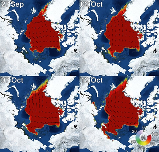
Fig 5: Forecast from Sea Ice Prediction model (Weathernews I-See Engine)